 The Villager Newspaper Online Your Community News – Cleveland's Westshore

Reservation Master Plans for each of the Cleveland Metropark District’s 18 parks have been updated since 2014. The Master Plans provide guidance for infrastructure maintenance, land protection, trail connections, and new initiatives in alignment with the Park District’s strategic goals. The plans utilize previous plans and inventories as a baseline and propose actions to take place over the next two to 20 years.
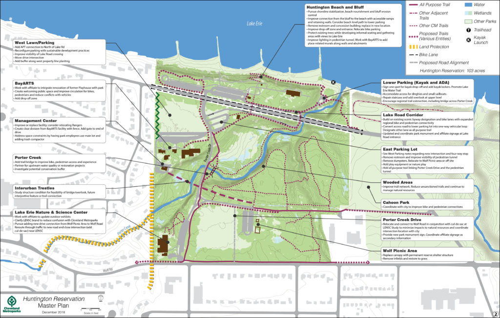
Click to view full size image.
West Lawn/Parking: Add APT connection to North of Lake Rd; Reconfigure parking with sustainable development practices; Improve visibility of Lake Road crossing; Move drive intersection; Add buffer along west property line planting
BayARTS: Work with affiliate to integrate renovation of former Playhouse with park; Create welcoming public space and improve circulation for bikes, pedestrians and reduce conflicts with vehicles; Add drop off zone
Management Center: Improve or replace facility; consider relocating Rangers; Create clear division from BayARTS facility with fence. Add gate to end of drive; Address space constraints by having park employees use main lot and adding trash compactor
Porter Creek: Add trail bridge to improve bike, pedestrian access and experience; Partner for upstream water quality or restoration projects; Investigate potential conservation buffer
Interurban Trestles: Study structure condition for feasibility of bridge/overlook, future interpretive feature or trail connection
Lake Erie Nature & Science Center: Work with affiliate to update outdoor exhibits; Clarify LENSC brand to reduce confusion with Cleveland Metroparks; Pursue adding new drive connection from Wolf Picnic Area to Wolf Road. Reroute through traffic to new road and close intersection (add cul-de-sac) near LENSC
Huntington Beach and Bluff: Pursue shoreline stabilization, beach nourishment and bluff erosion control; Improve connection from the bluff to the beach with accessible ramps and retaining walls. Consider beach level path to lower parking; Remove restroom and concession building; replace in new location; Improve drop-off zone and entrance. Relocate bike parking; Protect existing trees while developing informal seating and gathering areas with views to Lake Erie; Improve lighting in pedestrian tunnel. Work with BayARTS to add place-related murals along walls and abutments
Lower Parking (Kayak and ADA): Sign one spot for kayak drop-off and add kayak lockers. Promote Lake Erie Water Trail; Accommodate access for dinghies and small sailboats; Repair staircase and add overlook at upper level; Encourage regional trail connection, including bridge across Porter Creek
Lake Road Corridor: Build on existing scenic byway designation and bike lanes with expanded regional bike and pedestrian connectivity; Convert access road to lower parking lot into one-way vehicular loop. Designate other lane as all purpose trail; Updated and coordinate park monument and affiliate signage at Lake Road entrance
East Parking Lot: See West Parking notes regarding new intersection and four-way stop; Remove restroom and improve visibility of pedestrian tunnel; Remove dumpsters. Relocate to Wolf Picnic area or off site; Add play equipment or nature play; Add all purpose trail linking Porter Creek Drive and the pedestrian Tunnel
Wooded Areas: Improve trail network. Reduce unsanctioned trails and continue to manage natural resources
Cahoon Park: Coordinate with city to improve bike and pedestrian connections
Porter Creek Drive: Relocate and connect to Wolf Road in conjunction with cul-de-sac at LENSC Study to minimize impacts to natural resources and coordinate intersection location with city; Provide new park monument sign. Coordinate affiliate signage as secondary information
Wolf Picnic Area: Replace canopy with permanent reserve shelter structure: Remove infields and restore to grass